Waggy, West Virginia
Unincorporated community in West Virginia, United States
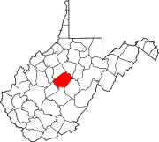
38°31′35″N 80°39′10″W / 38.52639°N 80.65278°W / 38.52639; -80.65278Waggy was an unincorporated community on the border of Braxton and Nicholas counties, West Virginia, United States, located just west of the Webster County line on the road from Bays to Erbacon and a logging railroad from Ramp Run. It was also known as Rose Hill.
The community was named after Henry Waggy, a businessperson in the lumber industry.[2]
References
- v
- t
- e
Municipalities and communities of Braxton County, West Virginia, United States
County seat: Sutton

communities
- Arnett
- Bison
- Bonnie
- Canfield
- Caress
- Centralia
- Chapel
- Clem
- Copen
- Corley
- Cutlips
- Dingy
- Duck
- Dutch
- Elmira
- Falls Mill
- Flower
- Frametown
- Gem
- Gip
- Glendon
- Heaters
- Herold
- Home
- Hyers
- Joppa
- Laurel Fork
- Letch
- Little Birch
- Little Otter
- McNutt
- Napier
- Newville
- Orlando‡
- Riffle
- Rollyson
- Rosedale
- Servia
- Strange Creek
- Tague
- Tesla
- Thrash
- Vernon
- Waggy‡
- Wilsie
‡This populated place also has portions in an adjacent county or counties
- West Virginia portal
- United States portal
 | This article about a location in Braxton County, West Virginia is a stub. You can help Wikipedia by expanding it. |
- v
- t
- e
 | This article about a location in Nicholas County, West Virginia is a stub. You can help Wikipedia by expanding it. |
- v
- t
- e


