Tuzla Spit
You can help expand this article with text translated from the corresponding article in Russian. (November 2010) Click [show] for important translation instructions.
- View a machine-translated version of the Russian article.
- Machine translation, like DeepL or Google Translate, is a useful starting point for translations, but translators must revise errors as necessary and confirm that the translation is accurate, rather than simply copy-pasting machine-translated text into the English Wikipedia.
- Do not translate text that appears unreliable or low-quality. If possible, verify the text with references provided in the foreign-language article.
- You must provide copyright attribution in the edit summary accompanying your translation by providing an interlanguage link to the source of your translation. A model attribution edit summary is
Content in this edit is translated from the existing Russian Wikipedia article at [[:ru:Тузлинская коса]]; see its history for attribution. - You may also add the template
{{Translated|ru|Тузлинская коса}}to the talk page. - For more guidance, see Wikipedia:Translation.
Sandbar in the Black Sea
Tuzla Spit Kosa Tuzla | |
|---|---|
Spit | |
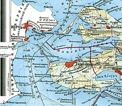 Tuzla Spit on a 1902 map of the Strait of Kerch. | |
45°16′0″N 36°33′0″E / 45.26667°N 36.55000°E / 45.26667; 36.55000 | |
| Location | Krasnodar Krai, Russia, Ukraine |
| Part of | Tuzla Island  |
Tuzla Spit or Kosa Tuzla (Russian: Тузлинская коса, Коса Тузла, Ukrainian: Коса Тузла)[1] was a long narrow peninsula or sandy spit in the eastern part of the Strait of Kerch which extended from Cape Tuzla [ru][2] to the north-west in the direction of the city Kerch for almost 11 kilometres (6.8 mi).
History
In 1925, the spit was cut by a storm, forming Tuzla Island. The open-water channel between Tuzla Island and the Russian mainland where the spit had previously existed reached over a kilometer in width.
Tuzla Spit consisted of the Tuzla Island (45°16′07″N 36°32′58″E / 45.26861°N 36.54944°E / 45.26861; 36.54944) and two small islands on the Russian side (45°13′33″N 36°35′34″E / 45.22583°N 36.59278°E / 45.22583; 36.59278 and 45°12′49″N 36°36′26″E / 45.21361°N 36.60722°E / 45.21361; 36.60722), and a narrow sand bar connecting them all. The two small islands were re-connected to each other by the 2003 construction by Russia of the 4.1 km long Tuzla dam (45°14′39″N 36°35′31″E / 45.24417°N 36.59194°E / 45.24417; 36.59194).
The Tuzla Spit formed the southern shore of the Taman Bay; the northern shore is the Chushka Spit.

Crimean bridge
The remnants of the Tuzla Spit were utilized in the building of the Crimean Bridge.
See also
- Spits of the Sea of Azov
- Dolgaya Spit
- Arabat Spit
References
- ^ Kosa Tuzla: Ukraine Geographic Names
- ^ Mys Tuzla, Krasnodarskiy Kray, Russia Mindat.org
External links
- «Остров Тузла» — Севастополь «ОК», № 1-2, 2000 г.
- «Коса Тузла» — Тамань. Ру > Фотогалерея > Коса Тузла
- Фотография окончания искусственной косы с воздуха
- Лист карты L-37-98 Тамань. Масштаб: 1 : 100 000. Состояние местности на 1988 год. Издание 1989 г.
- Лист карты L-37-XXV Аршинцево. Масштаб: 1:200 000. Издание 1982 г.
Wikimedia Commons has media related to Tuzla Spit.


