Tunney's Pasture station
Transit station in Ottawa, Canada
| Preceding station | Following station | |||
|---|---|---|---|---|
| Terminus | Line 1 | Bayview toward Blair | ||
| Westboro toward Bells Corners | Route 57 | Terminus | ||
| Westboro toward Stittsville | Route 61 | |||
| Route 62 | ||||
| Westboro toward Innovation | Route 63 | |||
| Westboro toward Riverview | Route 74 | |||
| Westboro toward Cambrian | Route 75 | |||
| Preceding station | Following station | |||
|---|---|---|---|---|
| Westboro toward Algonquin | Line 1 Opens 2026 | Bayview toward Trim | ||
| Westboro toward Moodie | Line 3 Opens 2026 | |||
Tunney's Pasture is the western O-Train light rail terminal train station in Ottawa, Ontario.
Location
It is located at the Tunney's Pasture government office complex, on Scott Street at Holland Avenue.
History
When originally opened in 1983, the transitway in the area consisted of a through station in a below-grade 'trench' parallel to Scott Street. Each platform had an elevator and stairway to the ground level above; the two sides were connected by an enclosed pedestrian bridge, and the ground-level station area also has platforms for local buses.
On 10 May 2003, an arson at the station inflicted damage estimated at $400,000 to $500,000 CAD. The fire left portions of the station out of service for months.[1][2]
On June 24, 2016, the transitway station was closed for conversion to light rail, and reopened in 2019 as the western terminus of the first phase of the Confederation Line. There are provisions to permit the Confederation Line to extend further west along the transitway in the next stage.
Layout
The station is a side platform station built below grade in a cutting. At street level, a broad concourse with two ticket barriers gives access to Scott Street and Tunney's Pasture Driveway. It also provides access within the fare-paid zone to the transitway terminal loop, allowing transfer between the bus and train without having to show a ticket or transfer.
As a terminus station, both platforms are used as arrival and departure platforms. Because of the station's side platform rather than island platform layout, displays on the concourse level are necessary to indicate which platform will next have a train departing.
The station features the artwork Gradient Space by Derek Root, a set of coloured mosaics lining the platform walls accompanied by a stained-glass skylight.[3]
Service
The following routes serve Tunney's Pasture station as of October 6, 2019:[4]
| |
|---|---|
   | O-Train |
| E1 | Shuttle Express |
| R1 R2 R4 | O-Train replacement bus routes |
| 98 39 | Rapid routes |
| N75 | Night routes |
| 40 11 | Frequent routes |
| 55 162 | Local routes |
| 284 | Connexion routes |
| 405 | 300s: Shopper routes 400s: Event routes 600s: School routes |
| Additional info:
| |
| Stop | Routes |
|---|---|
| East O-Train | |
| A Peak West | 164 251 252 256 257 258 261 262 263 264 265 266 267 268 |
| B Transitway West | 57 61 62 63 64 66 67 |
| C Rail Replacement | R1 N57 N61 N75 |
| D Local South/West | 11 16 50 51 80 81 86 87 89 153 |
| E Local East | 11 14 16 53 54 56 61 63 66 75 |
| F Transitway South | 73 74 75 82 |
| G Peak South | 270 271 272 273 277 278 282 283 284 |
| H Scott St. West | none |
Gallery
-
 Track level platform
 -
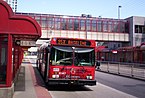
 The bus loop at Tunney's Pasture station
 -
 The former Transitway station in 2007, taken from above the Transitway
 -
 The former transitway station in 2007, facing eastbound


References
- ^ The Ottawa Citizen (11 May 2003). "City/Region". Ottawa Citizen. p. A9.
Suspected arsons investigated
- ^ "Tunney's Pasture station firebombing update". Ottawa Transit Bulletin. Ottawa Transit Riders Association. July 2003. Archived from the original on 2007-09-30.
- ^ "O-Train Confederation Line". City of Ottawa. Retrieved 17 September 2019.
- ^ "Tunney's Pasture | OC Transpo". Retrieved October 10, 2019.
External links
Wikimedia Commons has media related to Tunney's Pasture station.
- OC Transpo station page
- OC Transpo area map with location of main buildings of Tunney's Pasture
OC Transpo services in Ottawa | |||||||||||||||||||
|---|---|---|---|---|---|---|---|---|---|---|---|---|---|---|---|---|---|---|---|
| |||||||||||||||||||
| |||||||||||||||||||
| |||||||||||||||||||