Point Frederick, New South Wales
Suburb of Central Coast, New South Wales, Australia
| Point Frederick Central Coast, New South Wales | |||||||||||||||
|---|---|---|---|---|---|---|---|---|---|---|---|---|---|---|---|
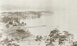 An early view from Presidents Hill showing Point Frederick | |||||||||||||||
 | |||||||||||||||
| Population | 1,927 (2016 census)[1] | ||||||||||||||
| • Density | 3,210/km2 (8,300/sq mi) | ||||||||||||||
| Postcode(s) | 2250 | ||||||||||||||
| Elevation | 14 m (46 ft) | ||||||||||||||
| Area | 0.6 km2 (0.2 sq mi) | ||||||||||||||
| Location |
| ||||||||||||||
| LGA(s) | Central Coast Council | ||||||||||||||
| Parish | Gosford | ||||||||||||||
| State electorate(s) | Gosford | ||||||||||||||
| Federal division(s) | Robertson | ||||||||||||||
| |||||||||||||||
Point Frederick is a suburb of the Central Coast region of New South Wales, Australia on a peninsula protruding into Brisbane Water 2 kilometres (1 mi) south-southeast of Gosford's central business district. It is part of the Central Coast Council local government area.
Pioneer Park
Point Frederick is one of the oldest areas on the Central Coast and is also home to Pioneer Park. Pioneer Park has great historical significance and hosts a graveyard in which various inhabitants of the point were buried long ago. Pioneer Park is also a popular outing place for tourists, and many families, to enjoy picnics.
References
- ^ Australian Bureau of Statistics (27 June 2017). "Point Frederick (State Suburb)". 2016 Census QuickStats. Retrieved 19 March 2018.

33°25′55″S 151°20′06″E / 33.432°S 151.335°E / -33.432; 151.335
- v
- t
- e
Suburbs of the Central Coast, New South Wales
and localities
- Alison
- Avoca Beach
- Bar Point
- Bateau Bay
- Bensville
- Berkeley Vale
- Blackwall
- Blue Bay
- Blue Haven
- Booker Bay
- Bouddi
- Box Head
- Budgewoi
- Budgewoi Peninsula
- Buff Point
- Bushells Ridge
- Calga
- Canton Beach
- Cedar Brush Creek
- Central Mangrove
- Chain Valley Bay
- Charmhaven
- Cheero Point
- Chittaway Bay
- Chittaway Point
- Cogra Bay
- Colongra
- Copacabana
- Crangan Bay
- Daleys Point
- Davistown
- Dooralong
- Doyalson
- Doyalson North
- Durren Durren
- East Gosford
- Empire Bay
- Erina
- Erina Heights
- Ettalong Beach
- Forresters Beach
- Fountaindale
- Glenning Valley
- Glenworth Valley
- Gorokan
- Gosford
- Green Point
- Greengrove
- Gunderman
- Gwandalan
- Halekulani
- Halloran
- Hamlyn Terrace
- Hardys Bay
- Holgate
- Horsfield Bay
- Jilliby
- Kangy Angy
- Kanwal
- Kariong
- Kiar
- Killarney Vale
- Killcare
- Killcare Heights
- Kincumber
- Kincumber South
- Kingfisher Shores
- Koolewong
- Kulnura
- Lake Haven
- Lake Munmorah
- Lemon Tree
- Lisarow
- Little Jilliby
- Little Wobby
- Long Jetty
- Lower Mangrove
- MacMasters Beach
- Magenta
- Mangrove Creek
- Mangrove Mountain
- Mannering Park
- Mardi
- Marlow
- Matcham
- Moonee
- Mooney Mooney
- Mooney Mooney Creek
- Mount Elliot
- Mount White
- Narara
- Niagara Park
- Norah Head
- Noraville
- North Avoca
- North Gosford
- Ourimbah
- Palm Grove
- Palmdale
- Patonga
- Pearl Beach
- Peats Ridge
- Phegans Bay
- Picketts Valley
- Point Clare
- Point Frederick
- Pretty Beach
- Ravensdale
- Rocky Point
- San Remo
- Saratoga
- Shelly Beach
- Somersby
- Spencer
- Springfield
- St Huberts Island
- Summerland Point
- Tacoma
- Tacoma South
- Tascott
- Ten Mile Hollow
- Terrigal
- The Entrance
- The Entrance North
- Toowoon Bay
- Toukley
- Tuggerah
- Tuggerawong
- Tumbi Umbi
- Umina Beach
- Upper Mangrove
- Wadalba
- Wagstaffe
- Wallarah
- Wamberal
- Warnervale
- Watanobbi
- Wendoree Park
- West Gosford
- Wisemans Ferry
- Wondabyne
- Woongarrah
- Woy Woy
- Woy Woy Bay
- Wyee
- Wyoming
- Wyong
- Wyong Creek
- Wyongah
- Yarramalong
- Yattalunga
other waterways
points of interest
 | This Central Coast geography article is a stub. You can help Wikipedia by expanding it. |
- v
- t
- e


