National Register of Historic Places listings in Breckinridge County, Kentucky

This is a list of the National Register of Historic Places listings in Breckinridge County, Kentucky.
This is intended to be a complete list of the properties and districts on the National Register of Historic Places in Breckinridge County, Kentucky, United States. The locations of National Register properties and districts for which the latitude and longitude coordinates are included below, may be seen in a map.[1]
There are 11 properties and districts listed on the National Register in the county.
This National Park Service list is complete through NPS recent listings posted June 21, 2024.[2]
Map all coordinates using OpenStreetMap
Download coordinates as:
- KML
- GPX (all coordinates)
- GPX (primary coordinates)
- GPX (secondary coordinates)
Current listings
| [3] | Name on the Register | Image | Date listed[4] | Location | City or town | Description |
|---|---|---|---|---|---|---|
| 1 | Cloverport Historic District |  | June 21, 1983 (#83002589) | Roughly bounded by 3rd, Main, Chestnut, and Lynn Sts. 37°50′11″N 86°37′54″W / 37.836389°N 86.631667°W / 37.836389; -86.631667 (Cloverport Historic District) | Cloverport | |
| 2 | Falls of Rough Historic District |  | January 31, 1978 (#78001305) | Kentucky Route 110 37°35′22″N 86°33′03″W / 37.589444°N 86.550833°W / 37.589444; -86.550833 (Falls of Rough Historic District) | Falls of Rough | |
| 3 | Fisher Homestead | Upload image | June 21, 1983 (#83002590) | U.S. Route 60 37°50′04″N 86°36′48″W / 37.834444°N 86.613333°W / 37.834444; -86.613333 (Fisher Homestead) | Cloverport | |
| 4 | Holt Bottoms Archeological District | Upload image | November 16, 1978 (#78001306) | Address Restricted | Holt | |
| 5 | Joseph Holt House and Chapel |  | July 12, 1976 (#76000853) | Southwest of Addison on Kentucky Route 144 37°54′38″N 86°34′39″W / 37.910556°N 86.5775°W / 37.910556; -86.5775 (Joseph Holt House and Chapel) | Addison | |
| 6 | Irvington Historic District | 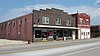 | June 29, 1998 (#97001342) | Roughly bounded by CSX tracks, Third, Caroline and Walnut Sts. 37°52′56″N 86°17′04″W / 37.882222°N 86.284444°W / 37.882222; -86.284444 (Irvington Historic District) | Irvington | |
| 7 | Mattingly Petroglyphs (15BC128) | Upload image | September 8, 1989 (#89001172) | Address Restricted | Mattingly | |
| 8 | North Fork Rough River Petroglyph (15BC130) | Upload image | September 8, 1989 (#89001174) | Address Restricted | Roff | |
| 9 | Oglesby-Conrad House | Upload image | June 21, 1983 (#83002591) | Off U.S. Route 60 37°49′57″N 86°38′53″W / 37.832500°N 86.648056°W / 37.832500; -86.648056 (Oglesby-Conrad House) | Cloverport | |
| 10 | Skillman House | Upload image | June 21, 1983 (#83002592) | Tile Plant Rd. 37°50′28″N 86°37′23″W / 37.841111°N 86.623056°W / 37.841111; -86.623056 (Skillman House) | Cloverport | |
| 11 | Tar Springs Petroglyphs (15BC129) | Upload image | September 8, 1989 (#89001173) | Address Restricted | Cloverport |
See also
Wikimedia Commons has media related to National Register of Historic Places in Breckinridge County, Kentucky.
References
- ^ The latitude and longitude information provided in this table was derived originally from the National Register Information System, which has been found to be fairly accurate for about 99% of listings. Some locations in this table may have been corrected to current GPS standards.
- ^ National Park Service, United States Department of the Interior, "National Register of Historic Places: Weekly List Actions", retrieved June 21, 2024.
- ^ Numbers represent an alphabetical ordering by significant words. Various colorings, defined here, differentiate National Historic Landmarks and historic districts from other NRHP buildings, structures, sites or objects.
- ^ The eight-digit number below each date is the number assigned to each location in the National Register Information System database, which can be viewed by clicking the number.
- v
- t
- e
- List of U.S. National Historic Landmarks by state:
- Alabama
- Alaska
- Arizona
- Arkansas
- California
- Colorado
- Connecticut
- Delaware
- Florida
- Georgia
- Hawaii
- Idaho
- Illinois
- Indiana
- Iowa
- Kansas
- Kentucky
- Louisiana
- Maine
- Maryland
- Massachusetts
- Michigan
- Minnesota
- Mississippi
- Missouri
- Montana
- Nebraska
- Nevada
- New Hampshire
- New Jersey
- New Mexico
- New York
- North Carolina
- North Dakota
- Ohio
- Oklahoma
- Oregon
- Pennsylvania
- Rhode Island
- South Carolina
- South Dakota
- Tennessee
- Texas
- Utah
- Vermont
- Virginia
- Washington
- West Virginia
- Wisconsin
- Wyoming
 National Register of Historic Places portal
 Category


Municipalities and communities of Breckinridge County, Kentucky, United States | ||
|---|---|---|
County seat: Hardinsburg | ||
| Cities |  | |
| Unincorporated communities | ||
| Footnotes | ‡This populated place also has portions in an adjacent county or counties | |
| ||


