Hundred-Mile Wilderness
Section of the Appalachian Trail in Maine, US
Map all coordinates using OpenStreetMap
Download coordinates as:
- KML
- GPX (all coordinates)
- GPX (primary coordinates)
- GPX (secondary coordinates)
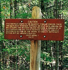
The Hundred-Mile Wilderness is the section of the Appalachian Trail running between Abol Bridge just south of Baxter State Park and Monson in the state of Maine. It is generally considered the wildest section of the Appalachian Trail,[1] and one of the most challenging to navigate and traverse. This section of the trail is crossed by several logging roads and is maintained by the Maine Appalachian Trail Club. It consists of a small corridor of protected wilderness surrounded by large tracts of public and private land controlled by paper companies. An increasing amount of the adjoining lands are being protected by groups like the Appalachian Mountain Club and the Nature Conservancy.
In 2000, a series of new logging roads and a marked side-trail offered hikers re-supply and lodging opportunities between miles 55 and 65 heading northbound from Monson.
45°36.9′N 69°9.8′W / 45.6150°N 69.1633°W / 45.6150; -69.1633 (Hundred-Mile Wilderness)
45°19′18″N 69°30′46″W / 45.32168°N 69.51286°W / 45.32168; -69.51286 (Monson, ME) 45°20′28″N 69°31′37″W / 45.34111°N 69.52685°W / 45.34111; -69.52685 45°22′46″N 69°28′14″W / 45.37952°N 69.47046°W / 45.37952; -69.47046 45°25′01″N 69°25′13″W / 45.41705°N 69.42029°W / 45.41705; -69.42029 45°24′56″N 69°22′14″W / 45.41559°N 69.37042°W / 45.41559; -69.37042 (Barren Mountain) 45°27′36″N 69°15′21″W / 45.46013°N 69.25597°W / 45.46013; -69.25597 (Chairback Mountain) 45°28′26″N 69°17′40″W / 45.47386°N 69.29442°W / 45.47386; -69.29442 45°30′59″N 69°19′20″W / 45.51645°N 69.32219°W / 45.51645; -69.32219 45°33′17″N 69°14′45″W / 45.55468°N 69.24592°W / 45.55468; -69.24592 (White Cap Mountain) 45°34′42″N 69°13′22″W / 45.57834°N 69.22268°W / 45.57834; -69.22268 45°36′54″N 69°09′48″W / 45.61499°N 69.16334°W / 45.61499; -69.16334 45°36′57″N 69°07′45″W / 45.61581°N 69.12928°W / 45.61581; -69.12928 45°39′36″N 68°59′34″W / 45.65995°N 68.99268°W / 45.65995; -68.99268 45°43′48″N 69°05′30″W / 45.73000°N 69.09156°W / 45.73000; -69.09156 45°49′17″N 69°09′55″W / 45.82129°N 69.16519°W / 45.82129; -69.16519 45°48′22″N 69°04′57″W / 45.80601°N 69.08242°W / 45.80601; -69.08242 45°50′06″N 68°58′02″W / 45.83496°N 68.96719°W / 45.83496; -68.96719 (Abol Bridge)
References
- ^ Bryson, Bill (December 26, 2006). A Walk in the Woods: Rediscovering America on the Appalachian Trail. Anchor. p. 238. ISBN 0307279464.
See also
- Maine Island Trail
- 100 Mile Wilderness Adventures
- v
- t
- e
Penobscot River Watershed
- Dead River
- East Branch Mattawamkeag River
- East Branch Penobscot River
- East Branch Piscataquis River
- East Branch Pleasant River
- Kenduskeag Stream
- Little Seboeis River
- Mattawamkeag River
- Middle Branch Pleasant River
- Molunkus Stream
- Narramissic River
- North Branch Marsh River
- North Branch Penobscot River
- Orland River
- Passadumkeag River
- Piscataquis River
- Pleasant River
- Sebec River
- Seboeis River
- South Branch Marsh River
- South Branch Penobscot River
- Stillwater River
- West Branch Mattawamkeag River
- West Branch Penobscot River
- West Branch Piscataquis River
- West Branch Pleasant River
- Allagash Lake
- Canada Falls Lake
- Caucomgomoc Lake
- Chamberlain Lake
- Chesuncook Lake
- Cold Stream Pond
- Debsconeag Lakes
- Grand Lake Seboeis
- Jo-Mary Lakes
- Lobster Lake
- Lower Wilson Pond
- Matagamon Lake
- Mattawamkeag Lake
- Millinocket Lake
- Nahmakanta Lake
- Nicatous Lake
- Lake Onawa
- Pemadumcook Chain of Lakes
- Pleasant Lake
- Pushaw Lake
- Ragged Lake
- Rainbow Lake
- Schoodic Lake
- Sebec Lake
- Seboeis Lake
- Seboomook Lake
- South Twin Lake
- Telos Lake
- Toddy Pond
- Upper Wilson Pond
- Abbot
- Bangor
- Bradley
- Brewer
- Brooks
- Brownville
- Bucksport
- Burlington
- Carmel
- Charleston
- Danforth
- Dover-Foxcroft
- East Millinocket
- Eddington
- Enfield
- Frankfort
- Guilford
- Hampden
- Haynesville
- Hermon
- Howland
- Hudson
- Island Falls
- Kenduskeag
- Kingman
- Lee
- Levant
- Lincoln
- Macwahoc
- Mattawamkeag
- Medway
- Milford
- Millinocket
- Milo
- Monson
- Oakfield
- Old Town
- Orland
- Orono
- Orrington
- Passadumkeag
- Patten
- Prospect
- Sangerville
- Sherman
- Smyrna
- Springfield
- Veazie
- Verona
- Winn
- Winterport
- Wytopitlock
- Bangor and Aroostook Railroad
- Baxter State Park
- Fort Knox
- Gero Island
- Great Northern Paper Company
- Great Works Dam
- Hundred-Mile Wilderness
- Katahdin Iron Works
- Maine Central Railroad
- Monson Railroad
- Mount Katahdin
- North Maine Woods
- Orono Dam
- Peaks-Kenny State Park
- Penobscot Indian Island Reservation
- Penobscot Narrows Bridge and Observatory
- Ripogenus Gorge
- Stillwater Dam
- University of Maine
- Veazie Dam
- Waldo–Hancock Bridge


