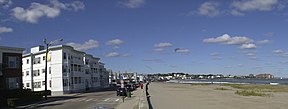
Winthrop Shore Drive
| Winthrop Shore Drive | |||
|---|---|---|---|
| National Register of Historic Places | |||
| Historic District | |||
 | |||
| |||
| Lage | Winthrop, Massachusetts, Vereinigte Staaten | ||
| Koordinaten | 42° 22′ 14″ N, 70° 58′ 5″ W42.370555555556-70.968055555556Koordinaten: 42° 22′ 14″ N, 70° 58′ 5″ W | ||
| Erbaut | 1899 | ||
| Architekt | Charles Eliot, Olmsted Brothers | ||
| NRHP-Nummer | 03001469[1] | ||
| Ins NRHP aufgenommen | 21. Januar 2004 | ||


Der Winthrop Shore Drive ist ein 1899 errichteter, vom Landschaftsarchitekten Charles Eliot in Zusammenarbeit mit dem Architekturbüro der Olmsted Brothers geplanter historischer Parkway in Winthrop im Bundesstaat Massachusetts der Vereinigten Staaten. Er führt unter anderem zum Winthrop Beach.
Die Straße wurde im Jahr 2004 als Historic District in das National Register of Historic Places eingetragen. Sie wird vom Department of Conservation and Recreation (DCR) verwaltet und ist Teil des Metropolitan Park System of Greater Boston.
Siehe auch
- Liste der Einträge im National Register of Historic Places im Suffolk County
Einzelnachweise
- ↑ National Register Information System. In: National Register of Historic Places. National Park Service, abgerufen am 13. März 2009 (englisch).
Department of Conservation and Recreation • Metropolregion Greater Boston • State Parks in Massachusetts


