Châtillon-sur-Indre
| Châtillon-sur-Indre | ||
|---|---|---|
 |
| |
| Staat | Frankreich | |
| Region | Centre-Val de Loire | |
| Département (Nr.) | Indre (36) | |
| Arrondissement | Châteauroux | |
| Kanton | Buzançais | |
| Gemeindeverband | Châtillonnais en Berry | |
| Koordinaten | 46° 59′ N, 1° 11′ O46.991.175Koordinaten: 46° 59′ N, 1° 11′ O | |
| Höhe | 82–148 m | |
| Fläche | 45,30 km² | |
| Einwohner | 2.304 (1. Januar 2021) | |
| Bevölkerungsdichte | 51 Einw./km² | |
| Postleitzahl | 36700 | |
| INSEE-Code | 36045 | |


Châtillon-sur-Indre ist eine französische Gemeinde mit 2304 Einwohnern (Stand 1. Januar 2021) im Département Indre in der Region Centre-Val de Loire; sie gehört zum Arrondissement Châteauroux und zum Kanton Buzançais. Der Ort liegt am Fluss Indre.
Nachbargemeinden sind Saint-Cyran-du-Jambot im Norden, Loché-sur-Indrois und Villedômain im Nordosten, Saint-Médard im Osten, Le Tranger im Südosten, Murs und Clion-sur-Indre im Süden, Cléré-du-Bois im Südwesten, und Fléré-la-Rivière im Westen.
Bevölkerungsentwicklung
| Jahr | 1962 | 1968 | 1975 | 1982 | 1990 | 1999 | 2008 | 2018 |
| Einwohner | 3479 | 3658 | 3624 | 3526 | 3262 | 3120 | 2859 | 2464 |
Sehenswürdigkeiten
- Burg Châtillon (12. Jahrhundert)
- Kirche Notre-Dame
- Schloss Pouzieux (15. Jahrhundert)
- Schloss Chaillou (16.–18. Jahrhundert)
- Priorei Saint-Martin-de-Vertou (15. Jahrhundert)
- Manoir de Menabre (15. Jahrhundert)
-
 Indre
Indre -
 Burg Châtillon
 -
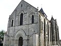 Kirche Notre-Dame


Persönlichkeiten
- Jean-Jacques Amelot de Chaillou (* 30. April 1689 in Chatillon sur Indre, † 7. Mai 1749 in Paris), Marquis de Combrande, Baron de Châtillon-sur-Indre, Politiker, 28. Juli 1727 Mitglied der Académie française (Sessel Nr. 10), Staatsminister 1737.
Städtepartnerschaft
- Solferino (Italien)
Literatur
- Pierre Brunaud, Jean-Louis Girault: Châtillon-sur-Indre et ses environs, de Saint-Genou à Fléré-la-Rivière. A. Sutton, Saint-Cyr-sur-Loire 2005, ISBN 2-84910-223-7.
Weblinks
Commons: Châtillon-sur-Indre – Sammlung von Bildern, Videos und Audiodateien


